-
Share You have indicated you have completed a detailed technical review of the impacts and hazards of the development. However, you seem to have left out a critical issue concerning how the development will impact the socio/economic status of the Naramata Bench and how it could detrimentally affect the City of Penticton in terms of loss of taxes, loss of jobs, etc. Can you please commit to conducting a detailed study to review what the Naramata Bench contributes to the City of Penticton and how this project could detrimentally affect the economy of the area? on Facebook
Share You have indicated you have completed a detailed technical review of the impacts and hazards of the development. However, you seem to have left out a critical issue concerning how the development will impact the socio/economic status of the Naramata Bench and how it could detrimentally affect the City of Penticton in terms of loss of taxes, loss of jobs, etc. Can you please commit to conducting a detailed study to review what the Naramata Bench contributes to the City of Penticton and how this project could detrimentally affect the economy of the area? on X (formerly Twitter)
Share You have indicated you have completed a detailed technical review of the impacts and hazards of the development. However, you seem to have left out a critical issue concerning how the development will impact the socio/economic status of the Naramata Bench and how it could detrimentally affect the City of Penticton in terms of loss of taxes, loss of jobs, etc. Can you please commit to conducting a detailed study to review what the Naramata Bench contributes to the City of Penticton and how this project could detrimentally affect the economy of the area? on Linkedin
Email You have indicated you have completed a detailed technical review of the impacts and hazards of the development. However, you seem to have left out a critical issue concerning how the development will impact the socio/economic status of the Naramata Bench and how it could detrimentally affect the City of Penticton in terms of loss of taxes, loss of jobs, etc. Can you please commit to conducting a detailed study to review what the Naramata Bench contributes to the City of Penticton and how this project could detrimentally affect the economy of the area? link
You have indicated you have completed a detailed technical review of the impacts and hazards of the development. However, you seem to have left out a critical issue concerning how the development will impact the socio/economic status of the Naramata Bench and how it could detrimentally affect the City of Penticton in terms of loss of taxes, loss of jobs, etc. Can you please commit to conducting a detailed study to review what the Naramata Bench contributes to the City of Penticton and how this project could detrimentally affect the economy of the area?
Bill Carpenter
asked
about 4 years ago
Should the application proceed back to Council for consideration, staff would include a detailed analysis of the financial implications of the proposed development. This would be included for the public's consideration. This work is underway currently.
-
Share This engagement is meant to have all issues on this clearly understood before the project goes to Council for approval. I watched the first online session and have read the Council report. It is unnerving that the City has not mentioned that approval from the Penticton Indian Band has been resolved before beginning this engagement. As you know, the Band stated publicly that it was against the first Canadian Horizons application. Why was the Band's approval not resolved prior to staff suggesting that Council send this second application to public engagement? on Facebook
Share This engagement is meant to have all issues on this clearly understood before the project goes to Council for approval. I watched the first online session and have read the Council report. It is unnerving that the City has not mentioned that approval from the Penticton Indian Band has been resolved before beginning this engagement. As you know, the Band stated publicly that it was against the first Canadian Horizons application. Why was the Band's approval not resolved prior to staff suggesting that Council send this second application to public engagement? on X (formerly Twitter)
Share This engagement is meant to have all issues on this clearly understood before the project goes to Council for approval. I watched the first online session and have read the Council report. It is unnerving that the City has not mentioned that approval from the Penticton Indian Band has been resolved before beginning this engagement. As you know, the Band stated publicly that it was against the first Canadian Horizons application. Why was the Band's approval not resolved prior to staff suggesting that Council send this second application to public engagement? on Linkedin
Email This engagement is meant to have all issues on this clearly understood before the project goes to Council for approval. I watched the first online session and have read the Council report. It is unnerving that the City has not mentioned that approval from the Penticton Indian Band has been resolved before beginning this engagement. As you know, the Band stated publicly that it was against the first Canadian Horizons application. Why was the Band's approval not resolved prior to staff suggesting that Council send this second application to public engagement? link
This engagement is meant to have all issues on this clearly understood before the project goes to Council for approval. I watched the first online session and have read the Council report. It is unnerving that the City has not mentioned that approval from the Penticton Indian Band has been resolved before beginning this engagement. As you know, the Band stated publicly that it was against the first Canadian Horizons application. Why was the Band's approval not resolved prior to staff suggesting that Council send this second application to public engagement?
Denis O'Gorman
asked
about 4 years ago
The purpose of engagement is to have an opportunity to share information with the public and key stakeholders and groups to better understand concerns and comments. City staff are following the process that the Penticton Indian Band requires for development applications, which includes a referral to be sent and specifics on the proposed development. Staff will continue to share information if needed and requested from the Penticton Indian Band.
-
Share Is it possible to have access to the financial model so that we can conduct an independent review of all parameters and methods? on Facebook
Share Is it possible to have access to the financial model so that we can conduct an independent review of all parameters and methods? on X (formerly Twitter)
Share Is it possible to have access to the financial model so that we can conduct an independent review of all parameters and methods? on Linkedin
Email Is it possible to have access to the financial model so that we can conduct an independent review of all parameters and methods? link
Is it possible to have access to the financial model so that we can conduct an independent review of all parameters and methods?
Bill Carpenter
asked
about 4 years ago
Should the application proceed back to Council for consideration, staff would include a detailed analysis of the financial implications of the proposed development. This would be included for the public's consideration. This work is underway currently.
-
Share Can you please provide us with a detailed overlay map showing where the building sites would be located taking into consideration; topography, environmentally sensitive areas, parks, wildlife corridors, landfill buffer, infrastructure easements, etc.? This seems to be absent from the proposal. on Facebook
Share Can you please provide us with a detailed overlay map showing where the building sites would be located taking into consideration; topography, environmentally sensitive areas, parks, wildlife corridors, landfill buffer, infrastructure easements, etc.? This seems to be absent from the proposal. on X (formerly Twitter)
Share Can you please provide us with a detailed overlay map showing where the building sites would be located taking into consideration; topography, environmentally sensitive areas, parks, wildlife corridors, landfill buffer, infrastructure easements, etc.? This seems to be absent from the proposal. on Linkedin
Email Can you please provide us with a detailed overlay map showing where the building sites would be located taking into consideration; topography, environmentally sensitive areas, parks, wildlife corridors, landfill buffer, infrastructure easements, etc.? This seems to be absent from the proposal. link
Can you please provide us with a detailed overlay map showing where the building sites would be located taking into consideration; topography, environmentally sensitive areas, parks, wildlife corridors, landfill buffer, infrastructure easements, etc.? This seems to be absent from the proposal.
Bill Carpenter
asked
about 4 years ago
There is a conceptual (draft) lot layout plan attached within the documents on shape your city that includes most of these items. However, the plan is conceptual at this time, as the land use is not yet confirmed and the lot sizes and proposed home locations could change.
-
Share Can you please clarify what the landfill buffer is going to be. The most recent CH proposal shows that it is 300 meters (Figure 10) whereas you have consistently stated that it will be 500 meters as per the RDOS recommendation? Please clarify. on Facebook
Share Can you please clarify what the landfill buffer is going to be. The most recent CH proposal shows that it is 300 meters (Figure 10) whereas you have consistently stated that it will be 500 meters as per the RDOS recommendation? Please clarify. on X (formerly Twitter)
Share Can you please clarify what the landfill buffer is going to be. The most recent CH proposal shows that it is 300 meters (Figure 10) whereas you have consistently stated that it will be 500 meters as per the RDOS recommendation? Please clarify. on Linkedin
Email Can you please clarify what the landfill buffer is going to be. The most recent CH proposal shows that it is 300 meters (Figure 10) whereas you have consistently stated that it will be 500 meters as per the RDOS recommendation? Please clarify. link
Can you please clarify what the landfill buffer is going to be. The most recent CH proposal shows that it is 300 meters (Figure 10) whereas you have consistently stated that it will be 500 meters as per the RDOS recommendation? Please clarify.
Bill Carpenter
asked
about 4 years ago
The applicant has proposed a 300m buffer be used for the proposed development of residential units. At this time, staff are recommending a 500m buffer from the landfill, which is from a report completed by the RDOS (operators of the landfill) that indicates sensitive uses (including residential) should not be within 500m of the landfill until such time a professional has completed further works and can confirm it is acceptable for residential to be closer to the landfill.
-
Share Having read Michael Hodges explanation of how the City's traffic consultant assesses a development's impact on intersections (in this 'Questions?' section), I have three questions:
1. Did the consultant consider the future impacts of traffic from other developments that are already in progress but not yet built out when he/she calculated the level of service of the key intersections? Naramata has several large developments underway, some partially built out and others in their very preliminary stages. These will result in a significant increase in population, hence a significant increase in number of vehicles on the Naramata Road.
2. Similar to question 1, was the Area E (Naramata) Official Community Plan considered in the traffic analysis? Densification of the village core and build out of commercial lots will also mean more traffic on the Naramata Rd.
3. At what time of year was the traffic analysis done? Which year was the data collected (i.e. was it done during Covid when much less traffic was on the roads?)
I didn't find answers to these questions in the Traffic Impact Assessment pdf. If there is another document that includes this information, please let me know where I can find it.
Thank you on Facebook
Share Having read Michael Hodges explanation of how the City's traffic consultant assesses a development's impact on intersections (in this 'Questions?' section), I have three questions:
1. Did the consultant consider the future impacts of traffic from other developments that are already in progress but not yet built out when he/she calculated the level of service of the key intersections? Naramata has several large developments underway, some partially built out and others in their very preliminary stages. These will result in a significant increase in population, hence a significant increase in number of vehicles on the Naramata Road.
2. Similar to question 1, was the Area E (Naramata) Official Community Plan considered in the traffic analysis? Densification of the village core and build out of commercial lots will also mean more traffic on the Naramata Rd.
3. At what time of year was the traffic analysis done? Which year was the data collected (i.e. was it done during Covid when much less traffic was on the roads?)
I didn't find answers to these questions in the Traffic Impact Assessment pdf. If there is another document that includes this information, please let me know where I can find it.
Thank you on X (formerly Twitter)
Share Having read Michael Hodges explanation of how the City's traffic consultant assesses a development's impact on intersections (in this 'Questions?' section), I have three questions:
1. Did the consultant consider the future impacts of traffic from other developments that are already in progress but not yet built out when he/she calculated the level of service of the key intersections? Naramata has several large developments underway, some partially built out and others in their very preliminary stages. These will result in a significant increase in population, hence a significant increase in number of vehicles on the Naramata Road.
2. Similar to question 1, was the Area E (Naramata) Official Community Plan considered in the traffic analysis? Densification of the village core and build out of commercial lots will also mean more traffic on the Naramata Rd.
3. At what time of year was the traffic analysis done? Which year was the data collected (i.e. was it done during Covid when much less traffic was on the roads?)
I didn't find answers to these questions in the Traffic Impact Assessment pdf. If there is another document that includes this information, please let me know where I can find it.
Thank you on Linkedin
Email Having read Michael Hodges explanation of how the City's traffic consultant assesses a development's impact on intersections (in this 'Questions?' section), I have three questions:
1. Did the consultant consider the future impacts of traffic from other developments that are already in progress but not yet built out when he/she calculated the level of service of the key intersections? Naramata has several large developments underway, some partially built out and others in their very preliminary stages. These will result in a significant increase in population, hence a significant increase in number of vehicles on the Naramata Road.
2. Similar to question 1, was the Area E (Naramata) Official Community Plan considered in the traffic analysis? Densification of the village core and build out of commercial lots will also mean more traffic on the Naramata Rd.
3. At what time of year was the traffic analysis done? Which year was the data collected (i.e. was it done during Covid when much less traffic was on the roads?)
I didn't find answers to these questions in the Traffic Impact Assessment pdf. If there is another document that includes this information, please let me know where I can find it.
Thank you link
Having read Michael Hodges explanation of how the City's traffic consultant assesses a development's impact on intersections (in this 'Questions?' section), I have three questions:
1. Did the consultant consider the future impacts of traffic from other developments that are already in progress but not yet built out when he/she calculated the level of service of the key intersections? Naramata has several large developments underway, some partially built out and others in their very preliminary stages. These will result in a significant increase in population, hence a significant increase in number of vehicles on the Naramata Road.
2. Similar to question 1, was the Area E (Naramata) Official Community Plan considered in the traffic analysis? Densification of the village core and build out of commercial lots will also mean more traffic on the Naramata Rd.
3. At what time of year was the traffic analysis done? Which year was the data collected (i.e. was it done during Covid when much less traffic was on the roads?)
I didn't find answers to these questions in the Traffic Impact Assessment pdf. If there is another document that includes this information, please let me know where I can find it.
Thank you
Sue K
asked
about 4 years ago
- Did the consultant consider the future impacts of traffic from other development that are already in progress but not yet built out when he/she calculated the level of service of the key intersection?
- Response: The traffic consultant allowed for a background traffic growth of 0.5% per year to 2030 to account for traffic increase. This was because there is no significant development in the OCP along Naramata road. If there was a significant development proposed within the City or Naramata itself that development would be responsible for the impact it will have on the roads.
- Similar to question 1, was the Area E (Naramata) Official Community Plan considered in the traffic analysis?
- Response: No it was not considered at this stage. It is not the responsibility of this developer to fund infrastructure for other developments. At this stage we are only looking at the impact of this development on the road network and it will be the responsibility of future developments to manage the impact that they have on the road network. I would mention that the City will looking the overall expected impact to this prior to any works taking place and ensure what is built will meet the future need, but that cost will not be paid by current development, but will be charge to the development that triggered the additional works.
- At what time of year was the traffic analysis done?
- Response: Traffic Count data was used from 2018, 2019 and 2020. These counts where analyzed by the traffic consultant to address the variances over the seasons and due to the pandemic. The traffic count data was increased by factors ranging from 5% to 55% to account for the expected variances.
-
Share The entire development appears to be in direct contradiction to the OCP requirements. Can you please explain how this proposed development fits with the OCP conditions to;
a. Keep a “compact” footprint to help protect natural areas, environmental values, agricultural lands, and avoid excessive infrastructure costs,
b. Focus new residential developments in or adjacent to existing areas
c. Avoid development in environmentally sensitive areas, geological and flood hazard areas, on steep slopes, on agricultural areas, and in areas not readily served by transit,
d. Encourage the development of compact, mixed use neighborhoods where appropriate, and support transit use, walking and cycling.
on Facebook
Share The entire development appears to be in direct contradiction to the OCP requirements. Can you please explain how this proposed development fits with the OCP conditions to;
a. Keep a “compact” footprint to help protect natural areas, environmental values, agricultural lands, and avoid excessive infrastructure costs,
b. Focus new residential developments in or adjacent to existing areas
c. Avoid development in environmentally sensitive areas, geological and flood hazard areas, on steep slopes, on agricultural areas, and in areas not readily served by transit,
d. Encourage the development of compact, mixed use neighborhoods where appropriate, and support transit use, walking and cycling.
on X (formerly Twitter)
Share The entire development appears to be in direct contradiction to the OCP requirements. Can you please explain how this proposed development fits with the OCP conditions to;
a. Keep a “compact” footprint to help protect natural areas, environmental values, agricultural lands, and avoid excessive infrastructure costs,
b. Focus new residential developments in or adjacent to existing areas
c. Avoid development in environmentally sensitive areas, geological and flood hazard areas, on steep slopes, on agricultural areas, and in areas not readily served by transit,
d. Encourage the development of compact, mixed use neighborhoods where appropriate, and support transit use, walking and cycling.
on Linkedin
Email The entire development appears to be in direct contradiction to the OCP requirements. Can you please explain how this proposed development fits with the OCP conditions to;
a. Keep a “compact” footprint to help protect natural areas, environmental values, agricultural lands, and avoid excessive infrastructure costs,
b. Focus new residential developments in or adjacent to existing areas
c. Avoid development in environmentally sensitive areas, geological and flood hazard areas, on steep slopes, on agricultural areas, and in areas not readily served by transit,
d. Encourage the development of compact, mixed use neighborhoods where appropriate, and support transit use, walking and cycling.
link
The entire development appears to be in direct contradiction to the OCP requirements. Can you please explain how this proposed development fits with the OCP conditions to;
a. Keep a “compact” footprint to help protect natural areas, environmental values, agricultural lands, and avoid excessive infrastructure costs,
b. Focus new residential developments in or adjacent to existing areas
c. Avoid development in environmentally sensitive areas, geological and flood hazard areas, on steep slopes, on agricultural areas, and in areas not readily served by transit,
d. Encourage the development of compact, mixed use neighborhoods where appropriate, and support transit use, walking and cycling.
Bill Carpenter
asked
about 4 years ago
The OCP does include OCP Goal 4.1.1 - Managing Residential Growth, which is what you have mentioned about retaining compact footprint, avoiding infrastructure costs and helping create conditions that support transit and active modes of transportation.
On page 55 of the OCP (before the page that contains OCP Goal 4.1.1), it speaks to the Housing Vision for Penticton, and acknowledges that "the future of housing development will require balancing sensitive hillside developments that is planned to avoid adverse ecological impacts and to minimize long term social and economic costs and appropriate and livable intensification of our existing neighbourhoods..."
There are other areas of the OCP (Page 44) that identify Spiller Road as a Growth Area for the City over the span of the OCP.
Keeping in mind that this is based on many years of policy work that identifies this area of the City as an area for growth. However, through this process we are asking the public whether this is an area of the City where the densities envisioned in the OCP are still desirable. Is the density too much? Does this still represent what we want to see on this property in the future? That is the conversation that we are here to have.
-
Share I would like to know the list of stakeholders who will be consulted on this issue, thanks. on Facebook
Share I would like to know the list of stakeholders who will be consulted on this issue, thanks. on X (formerly Twitter)
Share I would like to know the list of stakeholders who will be consulted on this issue, thanks. on Linkedin
Email I would like to know the list of stakeholders who will be consulted on this issue, thanks. link
I would like to know the list of stakeholders who will be consulted on this issue, thanks.
Loraine Stephanson
asked
about 4 years ago
The stakeholder and key engagement group list for this proposed development includes Ministry of Transportation and Infrastructure, Ministry of Agriculture, Ministry of Environment, BC Transit, Agricultural Land Commission, Penticton Indian Band, Regional District of Okanagan Similkameen, School District #67, Interior Health, the Society for the Preservation of the Naramata Bench, Naramata Bench Wineries, and the Chamber of Commerce.
-
Share Thanks for the info session last night, very helpful. At one point in the discussion about traffic, the planner mentioned that indications are that Naramata Road “won’t fail”. Can you provide an example of what the increased traffic will look like and what “won’t fail” means? The proposal says there is a Transportation Assessment filed, but I apologize I couldn’t find it if you could please direct me. Basically this proposal has the potential effect of increasing Naramata’s population by 25% so I would specifically like to understand the traffic from Reservoir Road, turning left onto Upper Bench Road, which already overflows the turning lane at times. A traffic circle at Reservoir and Naramata would be great (I’ve submitted before that’s a dangerous spot), but I just see the bottleneck pushed closer to the city and would like to know how much time sitting in traffic is allowed under the “won’t fail” definition. Thanks! Cindy on Facebook
Share Thanks for the info session last night, very helpful. At one point in the discussion about traffic, the planner mentioned that indications are that Naramata Road “won’t fail”. Can you provide an example of what the increased traffic will look like and what “won’t fail” means? The proposal says there is a Transportation Assessment filed, but I apologize I couldn’t find it if you could please direct me. Basically this proposal has the potential effect of increasing Naramata’s population by 25% so I would specifically like to understand the traffic from Reservoir Road, turning left onto Upper Bench Road, which already overflows the turning lane at times. A traffic circle at Reservoir and Naramata would be great (I’ve submitted before that’s a dangerous spot), but I just see the bottleneck pushed closer to the city and would like to know how much time sitting in traffic is allowed under the “won’t fail” definition. Thanks! Cindy on X (formerly Twitter)
Share Thanks for the info session last night, very helpful. At one point in the discussion about traffic, the planner mentioned that indications are that Naramata Road “won’t fail”. Can you provide an example of what the increased traffic will look like and what “won’t fail” means? The proposal says there is a Transportation Assessment filed, but I apologize I couldn’t find it if you could please direct me. Basically this proposal has the potential effect of increasing Naramata’s population by 25% so I would specifically like to understand the traffic from Reservoir Road, turning left onto Upper Bench Road, which already overflows the turning lane at times. A traffic circle at Reservoir and Naramata would be great (I’ve submitted before that’s a dangerous spot), but I just see the bottleneck pushed closer to the city and would like to know how much time sitting in traffic is allowed under the “won’t fail” definition. Thanks! Cindy on Linkedin
Email Thanks for the info session last night, very helpful. At one point in the discussion about traffic, the planner mentioned that indications are that Naramata Road “won’t fail”. Can you provide an example of what the increased traffic will look like and what “won’t fail” means? The proposal says there is a Transportation Assessment filed, but I apologize I couldn’t find it if you could please direct me. Basically this proposal has the potential effect of increasing Naramata’s population by 25% so I would specifically like to understand the traffic from Reservoir Road, turning left onto Upper Bench Road, which already overflows the turning lane at times. A traffic circle at Reservoir and Naramata would be great (I’ve submitted before that’s a dangerous spot), but I just see the bottleneck pushed closer to the city and would like to know how much time sitting in traffic is allowed under the “won’t fail” definition. Thanks! Cindy link
Thanks for the info session last night, very helpful. At one point in the discussion about traffic, the planner mentioned that indications are that Naramata Road “won’t fail”. Can you provide an example of what the increased traffic will look like and what “won’t fail” means? The proposal says there is a Transportation Assessment filed, but I apologize I couldn’t find it if you could please direct me. Basically this proposal has the potential effect of increasing Naramata’s population by 25% so I would specifically like to understand the traffic from Reservoir Road, turning left onto Upper Bench Road, which already overflows the turning lane at times. A traffic circle at Reservoir and Naramata would be great (I’ve submitted before that’s a dangerous spot), but I just see the bottleneck pushed closer to the city and would like to know how much time sitting in traffic is allowed under the “won’t fail” definition. Thanks! Cindy
Cindyb
asked
about 4 years ago
This question would have been answered by the City's Development Engineer. Please see the following information also provided for your question, and Michael's contact information at the bottom.
The way we look at intersection analysis is based on Level of Service for Motorists. We specifically look at traffic delay during peak traffic times, in the morning and in the afternoon. The philosophy that we look at for intersection is that we accept that during peak events there will be some delay for Motorists. While there are some delays during peak events, the delay for the rest of the time is significantly less. The Official Community Plan identify that in Penticton we are not designing our roads oversized to handle peak traffic events.
How do we do this
While the following explanation is very simplified it does outline how we look at capacity analysis for intersections, the actual analysis is much more nuanced than explained here.
The traffic consultant looks at the proposed development and based on Transportation Association of Canada guidelines determines how much traffic will be generated by the proposed development. The traffic engineer, in consultation with the City, determine where that traffic is expected to travel during peak times. In this case the traffic is between the Development and the City (heading to/from schools and employment), using a few different routes. While we know there will be traffic headed to Naramata, or other locations, we need to make assumptions. The developer adds the traffic generated by the development to the traffic actually counted on the intersections, giving a total traffic expected for each intersection. Through computer modeling they determine the delay each car will experience through the intersection during peak times. This average delay is used to determine the level of service of the intersection.
The table below outlines the breakdown of the Levels of Service in seconds for intersections. The City’s typical range for considering an intersection to “fail”, and as such requiring capacity upgrades, is in the Level of Service D, or E, depending on a number of factors. When looking at the impact of traffic from a development we look at changes to the Level of service, so if the intersection is a C before the Development and a C after the development we consider the development as not having a significant impact on the traffic.

Development results
While the proposed development does have an impact on the intersections causing minor increases in delay in Seconds, it does not significantly impact the Level of Service on intersections.
Looking at Upper bench and McMillian road. The intersection currently preforms at a Level of Service A on all directions in the morning peak and under the future development conditions it still continues to function at a level of service A. The average delay goes from 7.9 seconds to 8.1 seconds, so there is an impact, but it is very minor.
When we look at McMillian and Natamata road we see the traffic exiting Reservoir Road is at a level of service B today and with the future development causing the level of service to drop to a C. The average delay drops from 14.8 Seconds today to 19.3 Seconds in the future. If we are looking at the intersection without the development, but the typical growth increases, it also drops from a Level of Service B to C weather or not the development actually occurs. In this case we are proposing to require the developer to upgrade this intersection.
If you have any questions please contact the City’s Development Infrastructure Manager Michael Hodges Michael.hodges@penticton.ca
-
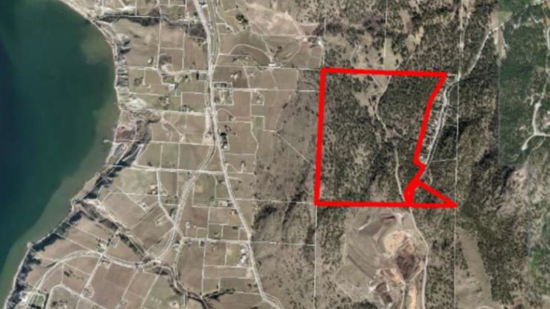
Share How can the City of Penticton prevent Canadian Horizons’ from clear cutting the forest at 1050 Spiller Rd?
A much smaller development named Vista on Arawana Rd above Naramata has clear cut the forest and the damage to the landscape can be seen from across the lake in Summerland. Canadian Horizons' proposal is approximately 3 times larger.
How can the City of Penticton prevent Canadian Horizons’ from clear cutting the forest at 1050 Spiller Rd? on Facebook
Share How can the City of Penticton prevent Canadian Horizons’ from clear cutting the forest at 1050 Spiller Rd?
A much smaller development named Vista on Arawana Rd above Naramata has clear cut the forest and the damage to the landscape can be seen from across the lake in Summerland. Canadian Horizons' proposal is approximately 3 times larger.
How can the City of Penticton prevent Canadian Horizons’ from clear cutting the forest at 1050 Spiller Rd? on X (formerly Twitter)
Share How can the City of Penticton prevent Canadian Horizons’ from clear cutting the forest at 1050 Spiller Rd?
A much smaller development named Vista on Arawana Rd above Naramata has clear cut the forest and the damage to the landscape can be seen from across the lake in Summerland. Canadian Horizons' proposal is approximately 3 times larger.
How can the City of Penticton prevent Canadian Horizons’ from clear cutting the forest at 1050 Spiller Rd? on Linkedin
Email How can the City of Penticton prevent Canadian Horizons’ from clear cutting the forest at 1050 Spiller Rd?
A much smaller development named Vista on Arawana Rd above Naramata has clear cut the forest and the damage to the landscape can be seen from across the lake in Summerland. Canadian Horizons' proposal is approximately 3 times larger.
How can the City of Penticton prevent Canadian Horizons’ from clear cutting the forest at 1050 Spiller Rd? link
How can the City of Penticton prevent Canadian Horizons’ from clear cutting the forest at 1050 Spiller Rd?
A much smaller development named Vista on Arawana Rd above Naramata has clear cut the forest and the damage to the landscape can be seen from across the lake in Summerland. Canadian Horizons' proposal is approximately 3 times larger.
How can the City of Penticton prevent Canadian Horizons’ from clear cutting the forest at 1050 Spiller Rd?
David Kozier
asked
about 4 years ago
The City has what is called a Hillside Development Permit Area, which this property is located within. The applicant will be required to obtain and adhere to many guidelines under this section of the OCP.
The intent of this Development Permit Area is to direct development on hillsides that respects the natural setting by minimizing risk from hazards, minimizing ecological and visual impacts and creating development that ‘settles’ into the landscape. The guidelines are also intended to mitigate the typical hillside challenges of low connectivity and poor walkability by making special efforts to create pedestrian and cycling connections.
You can view the Hillside Development Permit Area Guidelines within the City’s OCP, available on the City’s bylaw directory webpage.
There are also several areas of environmental significance on the property, which are reflected on the OCP Map to be designated for Natural and Conservation Areas. The City may require no disturb/no build covenants over these areas to ensure that current, prospective and future land owners are aware of these limitations. The purpose of these being to limit disturbance to protect the habitats of the area.
 Council Report Spiller Road Engagement Results (September 6, 2022).pdf (8.01 MB) (pdf)


